If you don't know what
SOTA is then click here
I'm fairly new to the SOTA
activation routine, and during a rather prolonged spell of gales with
no activations, decided to apply a more scientific approach to my
activations. Quite
simply I wanted to get the most points for the least amount of travel.
The outcome was a simple Visual Basic program that analyses the G, GW,
GM and GD summits and produces some league tables.
It has proved quite interesting to me, hi-lighting summits I have overlooked in the past and gives a slightly different perspective to the activations side of things. It is not a serious application and only took 7 hours to write including getting the data into the database, and thus some functions may not work in a fool-proof way. There's no charge and the latest version can be downloaded from here (546k).
There is no help or instructions. All there is, is what you read here.
Change history
Installation instructions
Unzip the .exe and .mdb files, into the same directory. You may already have the two .ocx files in your system directory, if you do, then use them. Mine are pretty old and don't cater for scrolling with the mouse wheel. If you try running SOTA_Planner and it complains about missing .OCX files then unzip the missing file and put it in the same directory as the .exe. So try running the .exe first.
Upgrade Information
1.0.0 to 1.1.0 No changes made to the database. Simply replace the old version of the .EXE
1.1.0 to 1.2.0 No changes made to the database. Simply replace the old version of the .EXE
Operating Instructions
You need to set the NGR of your QTH. All distance and bearings are relative to the NGR, so bearings are NOT true magnetic but close enough for pointing antenna etc. When the program first starts it will prompt for your NGR. The NGR can be amended from the Tools menu item. Please set an NGR when asked to, there're no checks.
After setting the "Global Options" and clicking "Run Query" you'll get a screen looking like this
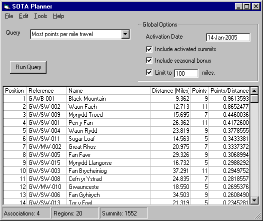
This screen indicates that Black Mountain gives the most number of points for the least amount of travel from my QTH. A surprise to me was Waun Fach at number 2. This hi-lights one problem. Distances are "as the crow flies". To drive to Waun Fach has got to be approx 30 miles as you have to drive around Black Mountain and several other lesser summits to get to it, but I guess you could walk from Black Mountain if feeling energetic !
You can sort the data by double-clicking on column title. Left mouse button will sort ascending, right mouse button will sort descending, e.g. double-clicking on "Distance (Miles)" produces.
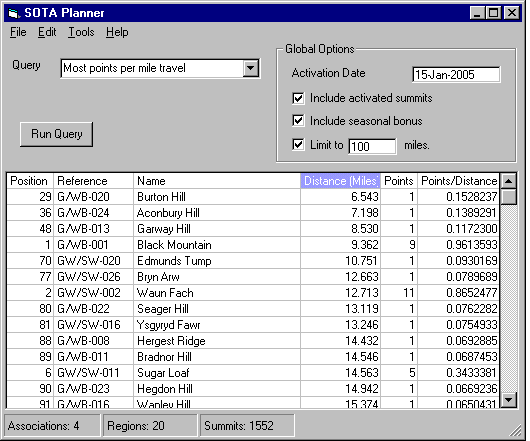
Which indicates that Burton Hill is my nearest summit and in the winter season comes in as nuimber 29. It moves up to number 11 in the summer.
Having decided on a summit, it'd be good to know if there are any other local summits you can activate at the same time. You can do that by double-clicking on the summit data - Reference, Name, Distance or "Points/Distance"
Double-clicking on the "Sugar Loaf" line brings up this screen. I could make this screen pop up quicker, because all the summits are in fixed locations relative to each other, so it should be a once off calculation and then saving the data in another database file, but quite frankly I can't be bothered. It's fast enough for me.
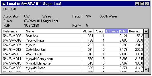
This screen is sorted on increasing distance, so indicates that Bryn Arw is just 2 miles walk away. Again you can sort (ascending or descending) by double-clicking left or right mouse buttons on the column headings.
The subject of Activations has been mentioned. To flag a summit as activated, this has to be done on the main screen. Simply double-click on the "Position" number corresponding to the summit. It'll get flagged in the database as having been activated as at the global option "Activation Date" and then you have to option not to see the summit again until next year when it will automagically reappear. There is a rough activations table maintenance program available in Tools->Maintenance. Use it at your peril. There's no validation on any of the data you put in there. The "reference" field is supposed to be the standard summit reference, i.e. <association>/<region>-nnn e.g. G/WB-001 and the "date_activated" field is a standard ASCII date in nn-mmm-yyyy format
Global Options Explained
Activation Date
This is the date used for the calculation of seasonal bonuses, and the date used to flag the summit as activated.
Include activated summits
After you have activated a few summits in the current year, you may not want to have them cluttering up the screens again. Check this box if you want to see them, uncheck it if you don't.
Include seasonal bonus
You may prefer not to include the seasonal bonus in calculations or in the "Points" available. Check this box if you want the seasonal bonus, uncheck it if you don't.
Limit to nnn miles/kilometres
You can select miles or kilometres by using "Tools"->"Units". It has global effect. Can be used to prune out summits that are too far away that would otherwise clutter up the screen when sorting.
Other stuff you need to know
There is only one query type, that is, the most points for the least travel. Haven't thought of anything else yet so the query drop down list only has one entry.
You'll notice some options are "greyed out". These existed so that I could load up the original database, and are not safe for public use, i.e. there's no form of validation on fields. I'm trying to prevent getting hassle from people that screw up their database.
Any queries/problem then click to email me. Leave the subject line alone. I get so much junk email that most are automatically deleted and never even downloaded off the server.
Mike de G0WZY
Various counters to see how often and by how many users. Gives me a vague idea on whether to maintain the page and/or the software.
It has proved quite interesting to me, hi-lighting summits I have overlooked in the past and gives a slightly different perspective to the activations side of things. It is not a serious application and only took 7 hours to write including getting the data into the database, and thus some functions may not work in a fool-proof way. There's no charge and the latest version can be downloaded from here (546k).
There is no help or instructions. All there is, is what you read here.
Change history
| Version |
Date Release | Changes |
| 1.2.0 |
15th January 2005 |
1. Resolved some problems
with re-sizing the forms. |
| 2. Added capability to
limit reports by distance, either miles of Km |
||
| 3. Double click left
mouse button will sort ascending. Double click right mouse button will
sort descending. |
||
| 1.1.0 |
9th January 2005 |
1. Added cells select and
cut to clipboard. Because of this, the click feature used to select a
summit for activation or to sort or to see the neighbours has been
changed to a double-click. |
| 2. Added table print,
either the whole lot or selected by page number |
||
| 3. You can ask for
bearings in a 8 or 16point compass, though why you'd want to is beyond
me. |
||
| 1.0.0 |
7th January 2005 |
Initial version |
Installation instructions
Unzip the .exe and .mdb files, into the same directory. You may already have the two .ocx files in your system directory, if you do, then use them. Mine are pretty old and don't cater for scrolling with the mouse wheel. If you try running SOTA_Planner and it complains about missing .OCX files then unzip the missing file and put it in the same directory as the .exe. So try running the .exe first.
Upgrade Information
1.0.0 to 1.1.0 No changes made to the database. Simply replace the old version of the .EXE
1.1.0 to 1.2.0 No changes made to the database. Simply replace the old version of the .EXE
Operating Instructions
You need to set the NGR of your QTH. All distance and bearings are relative to the NGR, so bearings are NOT true magnetic but close enough for pointing antenna etc. When the program first starts it will prompt for your NGR. The NGR can be amended from the Tools menu item. Please set an NGR when asked to, there're no checks.
After setting the "Global Options" and clicking "Run Query" you'll get a screen looking like this
This screen indicates that Black Mountain gives the most number of points for the least amount of travel from my QTH. A surprise to me was Waun Fach at number 2. This hi-lights one problem. Distances are "as the crow flies". To drive to Waun Fach has got to be approx 30 miles as you have to drive around Black Mountain and several other lesser summits to get to it, but I guess you could walk from Black Mountain if feeling energetic !
You can sort the data by double-clicking on column title. Left mouse button will sort ascending, right mouse button will sort descending, e.g. double-clicking on "Distance (Miles)" produces.
Which indicates that Burton Hill is my nearest summit and in the winter season comes in as nuimber 29. It moves up to number 11 in the summer.
Having decided on a summit, it'd be good to know if there are any other local summits you can activate at the same time. You can do that by double-clicking on the summit data - Reference, Name, Distance or "Points/Distance"
Double-clicking on the "Sugar Loaf" line brings up this screen. I could make this screen pop up quicker, because all the summits are in fixed locations relative to each other, so it should be a once off calculation and then saving the data in another database file, but quite frankly I can't be bothered. It's fast enough for me.
This screen is sorted on increasing distance, so indicates that Bryn Arw is just 2 miles walk away. Again you can sort (ascending or descending) by double-clicking left or right mouse buttons on the column headings.
The subject of Activations has been mentioned. To flag a summit as activated, this has to be done on the main screen. Simply double-click on the "Position" number corresponding to the summit. It'll get flagged in the database as having been activated as at the global option "Activation Date" and then you have to option not to see the summit again until next year when it will automagically reappear. There is a rough activations table maintenance program available in Tools->Maintenance. Use it at your peril. There's no validation on any of the data you put in there. The "reference" field is supposed to be the standard summit reference, i.e. <association>/<region>-nnn e.g. G/WB-001 and the "date_activated" field is a standard ASCII date in nn-mmm-yyyy format
Global Options Explained
Activation Date
This is the date used for the calculation of seasonal bonuses, and the date used to flag the summit as activated.
Include activated summits
After you have activated a few summits in the current year, you may not want to have them cluttering up the screens again. Check this box if you want to see them, uncheck it if you don't.
Include seasonal bonus
You may prefer not to include the seasonal bonus in calculations or in the "Points" available. Check this box if you want the seasonal bonus, uncheck it if you don't.
Limit to nnn miles/kilometres
You can select miles or kilometres by using "Tools"->"Units". It has global effect. Can be used to prune out summits that are too far away that would otherwise clutter up the screen when sorting.
Other stuff you need to know
There is only one query type, that is, the most points for the least travel. Haven't thought of anything else yet so the query drop down list only has one entry.
You'll notice some options are "greyed out". These existed so that I could load up the original database, and are not safe for public use, i.e. there's no form of validation on fields. I'm trying to prevent getting hassle from people that screw up their database.
Any queries/problem then click to email me. Leave the subject line alone. I get so much junk email that most are automatically deleted and never even downloaded off the server.
Mike de G0WZY
Various counters to see how often and by how many users. Gives me a vague idea on whether to maintain the page and/or the software.